

Assessment report of the recent landslide event in the Gyama Valley:
Its Possible Cause and Impacts
1. Introduction
On Friday, 29 March 2013, Chinese state media reported that 83 miners including two Tibetans had been buried after a major landslide hit a part of the Gyama (Ch:Jiama) Copper Polymetallic Mine, early morning at 6.00 local time. As of April 4, 66 miners have been confirmed dead and 17 are reported missing, believed dead.The workers were reportedly asleep in their tents when they were buried by a mass of mud, rocks and debris, three kilometers wide and 30 meters deep. The landslide occurred in the Pulang Valley in Siphug Village of Tashi Gang Town of Central Tibet. Tibet‟s rich mineral deposits have become a curse for the local residents and ecosystem. Since the late ‟60s, these mineral deposits have been exploited to various degrees, mostly under poor environmental norms and regulations. The minerals extracted, copper, chromium, gold, lead, iron and zinc are the minerals of greatest interest to both Chinese and other foreign miners operating in Tibet. These are being mined, to different extents, at various locations throughout the Tibetan Plateau. Now with strong policy backing from Beijing which has designated mining in Tibet as one of China‟s “Four Pillar” industries, Tibet‟s holy landscapes, lakes and pristine rivers will face more destruction, pollution. Most tragic of all local residents will have no option but to be silently witness the ecocide of the Tibetan Plateau. In a show of concern, President Xi Jinping, Premier Li Keqiang and Vice Premier Zhang Gaoli, all personally instructed officials to “spare no efforts” to rescue workers. This is indeed a very sad and unfortunate incident. However, the Chinese government must also “spare no efforts” to figure out the real cause of this tragedy, through sincere and transparent investigation putting aside political and social sensitivity of the issue. The Environment and Development Desk (DIIR) of the Central Tibetan Administration fear that this tragic incident could be a result of the aggressive expansion and large-scale exploitation of minerals in the Gyama Valley – a man-made phenomenon rather than merely a “natural disaster”.
2. Location Setting
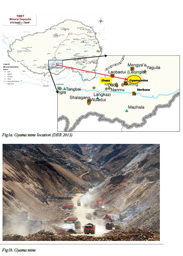
The Gyama mine is in Medrogungkar (Ch: Maizhokunggar) County of the so-called Tibet Autonomous Region (TAR), located within the Gangdise Porphyry Copper Metallogeny Belt in central Tibet, about 68 km from Lhasa (Figures 1a &1b). It is currently owned and operated by Tibet Huatailong Mining Development Company Limited, a subsidiary of China National Gold Group. It is a large scale polymetallic deposit consisting of copper, molybdenum, gold, silver, lead and zinc with the potential to become China‟s biggest copper producer in 10 years.
Gyama valley (Ch.: Jiama gou) situated south of the Lhasa River, is the historical birth place of Songtsen Gampo, one of the greatest Dharma kings of Tibet. The valley is also home to many sacred historical temples such as Gyelpo Khangkar, containing the image of Songtsen Gompo and his two foreign queens, Dumburi (a 12th century monastery) and Rinchen Gong monastery which was built in 1181. Thousands of Tibetans throng to the valley every year for pilgrimage.
The valley is a semi-agricultural area with nomadic animal husbandry. The upper part of the valley is dominated by pastures while the lower reaches are covered by farmland. The major crops are barley, wheat, rapeseed, peas and potatoes, along with husbandry of yak, sheep, cow and horses. The valley has three villages: Lungda, Trikhang and Tserong with a total population of around 3500.1
3. Historical development of the mine
As early as 1951, geological surveys were conducted and by 1991, a 3,600m long zone of copper-lead-zinc mineralization zone had been delineated. Between 1991 and 1999, number 6 Geological Brigade (Brigade 6) of the Tibet Geology and Mineral Resource Bureau conducted detailed exploration work. Based on this work, 4 mining licenses were issued to;
a. Gyama Township (began operations in 2004)
b. Lhasa Mining Company (began operations in 1995)
c. Brigade 6 (began operations in 2003) and
d. Tibet Huatailong Mining Development (began operations in 2005).
However, in April 2007, mining activities by the previous operators in the four mining license areas were stopped by the “TAR” government. In accordance with an agreement between the “TAR” government and China National Gold Group Corporation, the four mining licenses as well as the exploration licenses in the surrounding areas were consolidated under the Chinese government‟s consolidation policy for mining properties.
The Gyama Copper Polymetallic Mine has been selected as a “pilot of the National Green Mines Project” by the Ministry of Land and Resources (PRC) in 2012 and also as one of the “Model enterprises of national unity and progress”. As a requirement, the Gyama mine is supposed to meet higher standards of technology-oriented and corporate responsibility-oriented laws with adherence to policies of “people first” and “safe production” and to promote “harmony between the mine and the community and shoulder the responsibility of social welfare”.
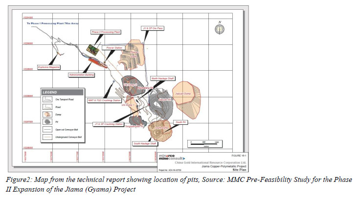
There has been rapid expansion of the mining operations which now cover a total of 145.50km2 including a mining area of 76.19km2 and exploration covering an area of 66.41km2 at an altitude between 4,000m and 5,407m. According to the company‟s assessment report, Gyama Copper Polymetallic Mine will have a total of 4 open pit mines and two underground mining areas (Figure 2). Open pit mines include, Niumatang (Depth: 610m, life: 8 years, Status: operational), Tongqianshan (Depth: 290m, life: 3 years, Status: operational), South Pit (Depth: 539m, life: 8 years, Status: Started in 2013) and Jiaoyan (Depth: 495m, life: 21 years, status: starting in 2020). Production has gone on since 2010 at a rate of 1.8 Mtpa ROM (Run Of Mine) ore at two open cut pits: Tongqianshan and Niumatang. The two underground mines are North Areas (life: 29 yrs) and South Areas (life: 21 yrs and starting in 2023).
The Mining Company is expected to get an average net cash flow of $120 million every year for the 31 years of LOM (Life of Mine). The key minerals produced are copper (Cu), gold (Au), silver (Ag), molybdenum (Mo), lead (Pb) and zinc (Zn). The contributions of these mineral ores to gross revenues are 75%, 11%, 7% and 6%. The mine is expected to get an annual production of 176 million pounds of copper, 35 thousand ounces of gold, 2.7 million ounces of silver and 2.3 thousand tonnes of molybdenum.
Last year, a Chinese state magazine carried an article with the title, „A Mining Miracle‟ which highly commended the efforts of Huatailong mining company to help, “restore the Tibetan region after private sector abuses”. It described the present state of the mining activity as having, “a panorama of lush green trees and grasslands, new roads and infrastructure, and cleaner mining facilities, giving the local people a better life.”6 China Daily, reported last year that the Gyama mine had hired 191 locals. It said non-Han employees made up 35% of the mine operator‟s staff, “the highest percentage among mining companies in China”.
4. Cause of Landslide: Chinese Government
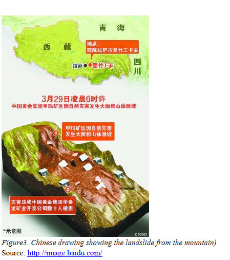
But all these claims of eco-friendly and mining safety were put to the test on 29 March 2013 by the massive landslide. A day after the landslide, Chinese state media and the Tibet Regional Propaganda Office were quick to portray the accident as a “natural disaster”, without giving any specifics. On 2 April, more details emerged through Chinese state media. Dorjee, an academic with the Chinese Academy of Engineering was quoted as saying, “The area from which the landslide originated was previously covered by large glaciers. Rocks hidden under the glaciers broke into smaller, loose rocks over a long period of time due to thermal expansion and contraction stress, as well as rainy and snowy weather.” He further stressed, “The smaller rocks near the source of the landslide collected together and snowballed into a massive landslide that was incredibly destructive” (Figure 3).
 Three days later, a six-member expert team led by Cen Jiafa, a researcher from the Ministry of Land and Resources presented their investigation report which reiterated and corroborated the previous argument. It was reported that steepness of the slope, disintegrating rock and water from snowmelt combined to cause the landslide. The report added, “The Mountain where the landslide occurred has a slope of up to 45 degrees and the drop along the 1,980-meter-long landslide is 824 meters high”.
However, several fundamental questions still remain unanswered.
• If rocks were disintegrated due to snowmelt and thermal dynamics, one should see similar cases of landslide in other regions covered with snow and glaciers across Tibet. So why did the landslide occur only at the site of mining and not anywhere else? Is this another „Mining Miracle‟?
• According to the company‟s website, the Gyama mine will “adhere to policies of people first and safe production”. Two-days before the landslide, China Gold’s chief executive Song Xin reportedly said that the Gyama mine adhered to high standards of occupational health, safety and environmental protection. If so, then why were the worker‟s camped so close to such a “natural geological hazard” and why was the “risk-emergency plan” launched only after the tragedy had struck?
• The Gyama mine has been hailed by Beijing as a flagship project. Several survey and inspections were carried out during the planning process of the mine. Why was the danger of loose rock not identified during the final technical feasibility study by the company as recommended by Minacro Mine Consult (MMC)? Is it just a coincidence that most of the rocks in the landslide were of similar looking shapes and sizes?
• Above all, why are officials trying to stop reporting of the event by not allowing the Chinese media to report freely and not even giving access to the foreign media? What is the government trying to hide the real cause, rights violations against Tibetans or corruption?
5. Possible cause(s) of Landslide in Gyama Mine
In order to acquire maximum profit in the shortest possible time, mining in Gyama has been pursued aggressively. Whole swathes of land have been excavated in several sites and in some cases the whole face of a mountain has been stripped off in the process of exploration, water diversion, mining and road construction. It was just a matter of time that such large scale and aggressive expansion of mining was going to cause a large scale disaster.
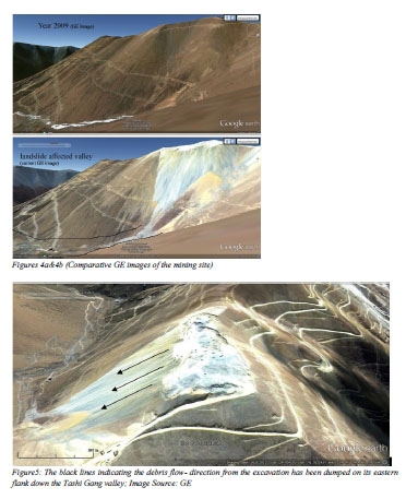
The Environment and Development Desk (EDD) of the Department of Information and International Relations (Central Tibetan Administration) believes that the landslide in Gyama is a man-made phenomenon rather than a natural disaster. However, we agree with aspects of the process suggested by the Chinese investigation team. The steepness of the slope and disintegration of rock were the key factors in causing this landslide. However, rocks were disintegrated into smaller pieces as part of the mining process and not due to glacial dynamics as Chinese officials are trying to make us believe. EDD has enough evidence to suggest that loose rock that turned into a landslide came from the surface mining at the top of the mountain which had been dumped on the eastern flank where the landslide originated (GE Figures 4 and 5).
First, we need to understand the amount of material being extracted and the resultant amount of debris which was dumped as waste in the process. Phase one of mining began in the second-half of 2010 with an annual mining and processing capacity of 6,000 tonnes a day. If 6000 tonnes per day is processed, it would amount to approx. 2.19 million tonnes per annum, which will add up to approx. 3.5 million tonnes for the 20 months from mid-2010 till March 2013. Since late 2012 or early 2013, it is evident that surface mining has been carried out at the top of a prominent mountain and an estimated 420 meter long and 250 meters wide area has been flattened. This is clearly evident from the Google Earth (GE) Image which shows some kind of mining activity on top of the mountain (coordinates 29042’13.00”N lat. and 21045’50.21”E long.) within the Gyama Copper Polymetallic Mining area.
One can compare the latest image with the previous ones (using the timeline option) to get a clear sense of the extent of excavation and also calculate the volume of material removed from the mountain.
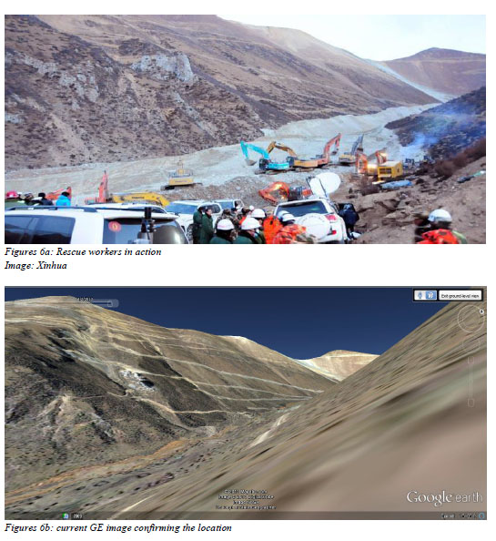
We also compared various, GE images, landslide images and video clips that were widely circulated in the Chinese media, and even invited a local resident who virtually took us to the ground zero with the help of Google Earth software. After painstakingly comparing various images, we came to the conclusion that the area of landslide that we have supposed from GE images matches exactly with the images circulated in the Chinese media. Even though, those Chinese images only captured the tongue of the landslide (Figures 6a) you could still clearly make out from the background that those GE images shown in figures 6b, 4 and 5 reference of the same location.
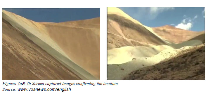
In addition to the above images, we captured some more screen shots from a recent Chinese clip (Figures 7a&7b) on the landslide incident and they too in a way confirm the geographical location in our argument (Figure 8).
Our rough calculation yielded an estimated 1.89 million cubic meters of material obliterated from the mountaintop after it was reduced to a flat ridge-like structure. The explosives used in mining would surely cause instability in the debris pile. The debris from the excavation was dumped on its eastern flank down the valley (newly formed light patch on the slope seen in all the images). According to the Chinese State media, the amount of material in the landslide is approximately 2 million cubic meters and it matches our calculation of the missing material from the mountaintop. The steepness of the mountain is around 45 degrees, as suggested by Chinese investigators. In the valley, GE image shows blue-roofed camps, possibly camps for worker which may be the one‟s buried by the landslide.
The debris from the landslide is of similar size and shape suggesting that it was not fragmented by any geological process like the thermal dynamics of glaciers but rather crushed into particular sizes by processing. According to the technical report of the company, excavated rocks will be crushed into sizes smaller than 300 mm. A natural landslide will cause rocks to disintegrate in varying size while a mechanized crushing would only yield rocks of defined sizes.
EDD believes that due to excessive dumping of these rock waste and tailings in the steep slopes of the mountain, the stability of the slope was disturbed and increased its vulnerability to fail. This factor was aided by high explosives and blasting agents used during the exploration carried out in the adjoining areas. At some point, when the slope could no longer hold the weight of several million tonnes of debris, the whole pile, which had low cohesion, plummeted down the valley and the ensuing force carried it 3 km’s away. This situation resembles the process of „debris avalanche‟ or „waste avalanche‟, which is a type of landslide characterized by the chaotic movement of rocks, soil and debris mixed with water or ice. Debris avalanches can also travel well past the foot of the slope due to their tremendous speed. Due to its swift slide, the miners in the camp possibly did not have any chance to escape. The picture of the landslide looks similar to a debris avalanche.
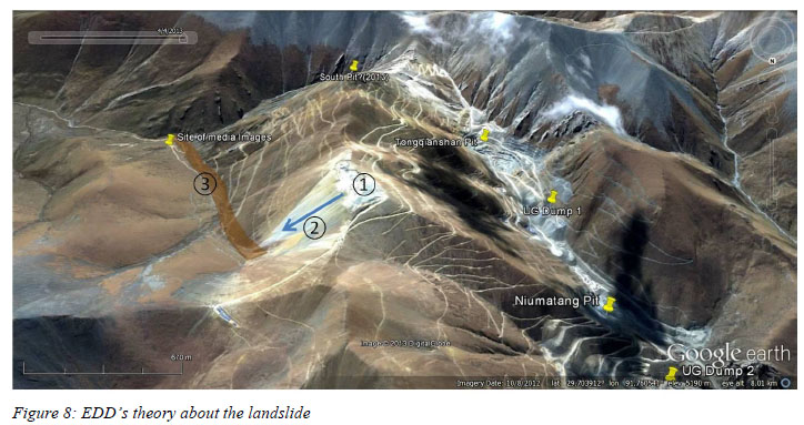
1. Possibly a surface excavation on top of the mountain
2. The waste ore/ mine tailing from the excavation is dumped on the eastern flank of the mountain (indicated by the blue arrow)
3. The brown shade indicates the valley that has been hit by the landslide; caused by the increased weight of the stockpile and possibly aided by the use of explosives for exploration drilling in the adjoining areas.
Image Source: GE
6. Media Restrictions and Reaction of Netizens in China
From the outset, all reports about the landslide were reported and supplied by Chinese state media. Foreign media has already been barred in Tibet since 2008 and the Chinese media personnel were given strict instructions not to diverge from the official position and cautioned from divulging any independent findings. An instruction, thought to be leaked from the Chinese Central Propaganda Department, ordered media outlets to “use Xinhua wire copy and information issued by authorities departments as the standard.” It specified: “No journalist to be sent to the region for reporting or interviewing.”
The disaster has drawn angry reactions against the authorities and strong sympathy for the Tibetans among the netizens in China. Many Internet users in China suggested that the landslide was likely caused by the devastation of the area‟s environment by uncontrolled and widespread mining activity. Beijing based writer Tsering Woeser, who has written about environmental problems in Tibet wrote, “This was not a natural but a man-made disaster”. She further stressed, “For locals, it says loud and clear how crazy the mining has become there.” Another blogger wrote that travelling along the Sichuan-Tibet freeway, there were countless mines, large and small. The road had been badly damaged by the hundreds of huge 80-tonne trucks carrying mineral ore out of the region each day.
Television director Zhang Ronggui said he was “strongly opposed to the development of heavy industry and mineral resources in Tibet” in a widely forwarded post on Sina Weibo (the Chinese Twitter equivalent). “It is the world‟s highest and purest holy land, and I hope the government can leave a blue sky, clean water and white clouds for the next generation,” he wrote. Well-known author Zhang Yihe, in a message to her 339,000 fans, said: “I don‟t understand why we have to dig up gold in areas that are above 4,000 meters. Why must we also build dams on rivers, including the Yarlung Zangbo? Why don‟t we leave something for the next generation?”
7. Recommendations of the Technical Report
Several Technical reports have been produced for the mining company in Gyama including an update report19 prepared by Behre Dolbear Asia, Inc. Denver, Colorado in March 2012 and a pre-feasibility study technical report for the phase II expansion of the Jiama project20 prepared by Minacro Mine Consult (MMC), Brisbane, Queensland, Australia, in November 2012.
MMC has noted five additional detailed mine planning studies that are required to conduct prior to operation. Of these, we believe the client must have ignored the three below:
1. Confirm, optimize and improve pit designs, scheduling and equipment selection for South Pit and Jiaoyan (this will require further geotechnical work but this work has the potential to improve project economics);
2. Confirm final design parameters for South Pit and Jiaoyan, particularly those relating to the overall pit slope angle of 43 degrees, which are considered conservative;
3. Confirm final design parameters used for the underground mine (this will require further geotechnical work);
MMC have mentioned in their technical report that further geotechnical studies should be undertaken to better understand the rock mechanics related to the Jiaoyan Pit, South Pit and the underground mine, (only qualitative descriptions regarding the stress distribution characteristics of rock mass in the rock mechanics and general estimates regarding the ground surface caving have been completed to date) MMC recommends further geotechnical work such as rock stress testing, research on rock mass strain properties and ground pressure observation and analysis.
8. Corruption: Interplay of politics and wealth
In accordance with an agreement between the „TAR‟ government and China National Gold Group Corporation, the four mining licenses in the Gyama valley as well as the exploration licenses in the surrounding areas were consolidated by the reorganized Huatailong in late 2007, with China Gold Group (Honk Kong) as the primary shareholder.21 However, the process of transferring ownership was not so simple. Several holding companies got involved in the deal including PRC based „Jia Ertong‟, Cayman Island Company „Skyland Mining‟ and British Virgin Island Company „Rapid Results Investment‟. The present owner, China Gold International Resources Corp. Ltd. (CGIR) came into the picture after it signed a purchase agreement on 30 August 2010 and agreed to pay over USD 700,000,000 worth of shares and about USD 50,000,000 in cash for the Gyama mine. As 49% owner, Rapid Result Investment (RRI) received about USD 375,000,000 in addition to USD 216,000,000 that it already received from PRC State Owned Enterprise China National Gold Group from the sale of its 51% share in the mine. Thus RRI received a total of about USD 590,000,000 in this whole transaction.
Rapid Result Investment is an investment holding company incorporated in the British Virgin Islands (BVI) on September 22, 2006. BVI, along with other offshore areas such as Cayman Islands, Samoa Islands etc. are used by many Chinese business owners and officials to conceal illegal conduct such as tax evasion and fraud by establishing offshore holding companies. Recently, on 4 April 2013, the International Consortium of Investigative journalists (ICIJ) began leaking the details of 2 million emails and other documents and journalists investigating British Virgin Islands data found that those setting up offshore entities were mostly from the Chinese mainland, HK and Taiwan.22 It may come to light that RPI, owned by various individuals and family trusts, is connected with the CCP in TAR and Beijing since they amassed huge wealth through the transfer of the ownships of the Gyama mine.
9. Socio-economic and Environmental Impacts
In the past decade, the Gyama mine has been a major failure in terms of the social harmony and environmental protection in the area. Before it was consolidated under one umbrella in 2007, the Gyamam Mine consisted of four small mines which were causing pollution, land degradation, harm to livestock etc. After the consolidation, large-scale and heavy mechanized operations accelerated the ongoing environmental and social problems.
Gyama valley is considered sacred and many Tibetans visit the valley on pilgrimage every year. But due to the rapid expansion, many monasteries, hermitages and centuries-old paintings have been affected. The lack of empathy by the Chinese government towards Tibetan Culture and sentiment is expressed by Tsering Woeser who wrote, “It is true that I mention Songtsen Gampo often, always in the hope that those greedy cadres and companies would show some mercy. In Han Chinese culture, the birthplace of all former dynasties‟ emperors is considered to be the treasured place of “fengshui”, referred to as “dragon‟s pulse […] Gyama, with its many sacred and beautiful places, is where the “dragon‟s pulse” exists in Tibet and it should never have to endure such disemboweling hardship as it does today.”
Due to the massive influx of Chinese migrants, Tibetans are left with very few employment opportunities and other benefits. The fact that only two of those trapped are Tibetan and the rest are Han Chinese migrant workers from neighboring provinces of Yunnan, Guizhou and Sichuan is a clear indicator. Many Tibetan farmers and nomads have been forced to move away from their ancestral pastures and arable lands which have been expropriated by government to make way for the expansion of mining operations in Gyama.
Reports of environmental pollution leading to water contamination, the illness of local Tibetans and loss of animals are common in the Gyama Valley. Huang and her associates (2010) conducted research on the environmental impact of mining activities on the surface water quality in the Gyama town near Lhasa and found: “high content of heavy metals in the stream sediments as well as in a number of tailings with gangue and material from the ore processing, poses a great potential threat to the downstream water users”. The mining, which has been going on in the upper hills of Gyama for nearly two decades has led to toxic waste being dumped into the Gyama Shingchu river resulting in the death of a large number of cattle. Villagers in the valley depend on Gyama Shingchu for their drinking water supply and irrigation. Tsering Woeser who went to Gyama in 2005, later wrote, “I heard that the elderly man who guards the temple already passed away. Because of the pollution caused by mining activities, many villagers have fallen ill.”
The impact of rampant mining activities has led to social unrest and related issues. In 2008, the Chinese mining company carried out a water-diversion project in the upper Gyama region leading to forceful confiscation of agricultural lands. In the same year, local Tibetan residents from Gyama Township reportedly petitioned the local government to put an immediate halt to the mining project in the area. The local government responded by putting the whole region under heavy military surveillance, with imposition of severe restrictions on communication to the outside world and people visiting the region.25 A positive response seems unlikely, as it will be at odds with the self-interests of many officials who make quasi-legal financial gains by protecting mining enterprises. On June 20, 2009, angry villagers took to streets and clashed with Chinese miners and the scuffle between Tibetans and miners were followed by police crackdown leaving 3 Tibetans wounded.26
10. Mining Accidents as a Norm in China
The mining and quarrying industry in China has a dreadful safety record and the list of mining-related accidents is long. On the same day when this massive landslide swept through a part of the Gyama mine, there were reports of explosions in two coal mines located in Jilin and Guizhou resulting in the death of 29 workers. The authorities put Babao coal mine in Jilin “under investigation”, but just three days later Babao witnessed another gas explosion, killing six more workers while 11 remain missing.
According to the data compiled by the United States Mine Rescue Association (USMRA), 19 incidents of mining-related accidents have been reported in China since the beginning of 2013, resulting in the death of at least 167 with 95 workers still missing.28 According to the official figures, at least 1,384 people died due to mining-related accidents in China in 2012 only. The figure in 2011 was higher at 1,973 and the State Administration of Work Safety (SAWS) claims “major progress” in reducing deaths. However, due to widespread practice of concealing or underreporting the full extent of mine disasters, the actual death tolls could be higher.29 The lack of a free press, independent trade unions, citizen watchdog groups and other checks on official power have enabled government officials to have better success rate in concealing a tragedy than preventing it.
In a rather similar case as Gyama, in the mainland China in Shanxi province, a landslide toppled a waste dump of the mine and buried Sigou Village of Loufan County claiming 45 lives on 1 August 2009. Chinese authorities later confirmed and accepted that poor mining management was the cause of the Sigou Village landslide in China. However, a landslide in a minority region such as those inhabited by Tibetans, Uyghurs and Mongolians provoke a different response from the authorities as it is viewed as politically and socially sensitive. On 31 July 2012, a landslide occurred in Araltobe, Xinyuan County in Kazak Autonomous Prefecture of Ili, in Xinjiang Uygur Autonomous Region and buried a building occupied by 28 people. After an “official investigation”, the local land resources authorities found that the disaster was a result of heavy rainfall.
11. Conclusion
Millions are suppressed from expressing their voices, limited information flows out of Tibet, there is heavy internet and media censorship, yet the truth prevails. Resource extraction is prevalent in more than 200 different sites across Tibet. Since 2009, there have been over 18 different cases of public protest related to the mining sector in all the three provinces of Tibet. These mining companies pay little respect to the local culture and the sanctity of the landscapes. They have been known to extract minerals and other resources from holy lakes and sacred mountains which local Tibetans have revered for generations. Such negligence and disrespect creates strong social tensions, distrust, anger, desperation and fear among the local residents.
Whenever Tibetan communities attempt to put forward their grievances against the miners in petitions to higher authorities, they are ignored, politicized and harassed or even fired upon by the police. In the frequent protests by Tibetan villagers, their immediate concern has often been the damage done by miners to the local streams, rivers, holy mountains and pasture land. Without any concern or hesitation, miners dump the mine tailing and chemical effluents in the local river with no particular attention nor action from the local authorities.
Towards this end, we demand a full investigation from an independent party to investigate and report the real cause of this landslide. More importantly we call on the Chinese government to ensure the active participation of the Tibetan people in all decision making processes in Tibet; that social, environmental (Environmental Impact Assessment) and cultural impacts are fully investigated; natural resources are not depleted; migration and settlement of non-Tibetans into Tibet are not facilitated; ownership of Tibetan land and resources are not transferred to non-Tibetans; and large-scale, capital-intensive and commercial projects are not facilitated inside Tibet.
Prepared by:
Environment & Development Desk
Department of Information and International Relations
Central Tibetan Administration
On April 9, 2013
comment 0